Greater Toronto Area Space Station Flyovers for the week of March 29th, 2020

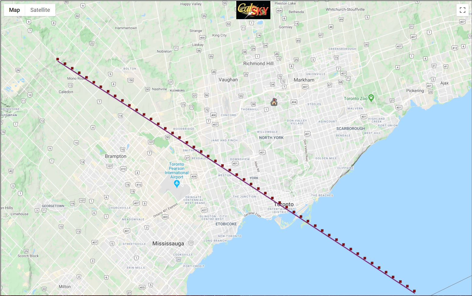
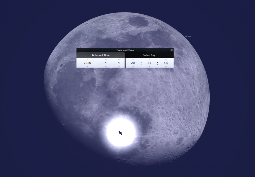
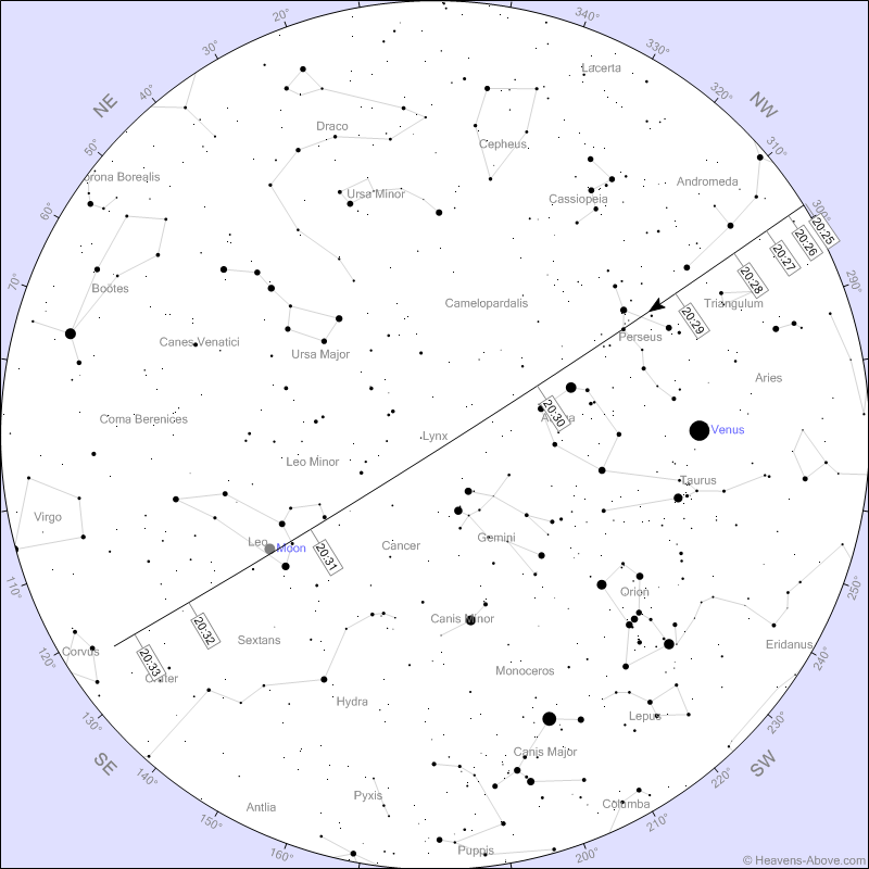
When the ISS flies over Toronto on Saturday, April 4 from 8:27 to 8:33 pm EDT, it will pass directly across the disk of the moon, but only for those watching along a narrow path through Toronto, which is shown here. If you wish to observe this event, please respect social distancing and directives from your local health officials. Events like this do occur from time to time – so we’ll have more chances once the COVID-19 crisis has passed.

Artificial satellites are visible because they are high enough to be bathed in sunlight while the sun is below the horizon for earthbound observers. When the geometry is just right, brilliant beams of sunlight are reflected to Earth from flat, shiny surfaces on the spacecraft – which we see as a steady point of light that crosses the night sky in mere minutes.
Low Earth orbiting satellites (LEOs) like the space station can only be seen within an hour or two of dusk and dawn (even though they are passing overhead at all hours of the day and night). Satellites with higher orbits can be seen throughout the night. Geostationary satellites such as telecom and satellite television transmitters need to broadcast toward specific regions of the Earth, so they are placed in very remote orbits that hold them fixed at a specific altitude and azimuth in the sky.
Engineers do not bother attaching lights to satellites. If you see a night sky object that has flickering or flashing lights, it’s an aircraft. Decommissioned satellites and space “junk”, such as spent rocket boosters, can smoothly vary in brightness if they are tumbling.
A very good website for satellite predictions is www.heavens-above.com. Click on the Location link and enter your geographic location – manually, or by dropping a pin on the provided map. Then return to the main page and select from the provided list of object types, such as “ISS”. Apps such as Sputnik!, ISS Detector, and Orbitrack will put satellite predictions in your pocket, alert you of imminent passes, and even show you where in the sky to look. The SkySafari app also includes an extensive satellite database.
The ISS (or International Space Station) is visible gliding silently over the GTA this week. The best passes at (mostly) convenient times are listed below. (Note: The more negative the Mag. number, the brighter it will look. The larger the Max Alt. number, the higher up in the sky it will be!) The higher and brighter passes are highlighted with “!!”. (Data adapted from www.Heavens-above.com. If you enter your location in their website, you will get a list of the passes for your location.) All the times below are expressed in Eastern Time.

This link should open a Google map of the ISS pass on the moon that you can zoom in on: https://www.calsky.com/?Transitline=&showhome=&obs=4106347130527775&tdt=2458944.52295044&sat=25544&interval=0.00011574&step=0.00000231&mainbody=10
| Date | Start & End Times (EDT) | Direction of Travel | Max Alt. | Mag. |
| Sun, 29-Mar | 8:20:59 pm to 8:26:17 pm | moves NW to NE | 21° | -1.7 |
| Sun, 29-Mar | 9:57:50 pm to 10:00:04 pm | moves NW to NNW | 32° | -2.1 |
| Mon, 30-Mar | 9:10:32 pm to 9:14:36 pm | moves NW to NE | 31° | -2.5 |
| Tue, 31-Mar | 8:23:11 pm to 8:28:58 pm | moves NW to ENE | 26° | -2.1 |
| Tue, 31-Mar | 9:59:50 pm to 10:02:07 pm | moves WNW to WNW | 40° | -2.4 |
| Wed, 1-Apr | 9:12:29 pm to 9:16:40 pm | moves NW to E | 60° | -3.6 !! |
| Thu, 2-Apr | 8:25:08 pm to 8:31:16 pm | moves NW to E | 42° | -3.0 !! |
| Thu, 2-Apr | 10:02:04 pm to 10:04:15 pm | moves WNW to WSW | 28° | -2.0 |
| Fri, 3-Apr | 9:14:30 pm to 9:18:53 pm | moves WNW to SSE | 53° | -3.3 !! |
| Sat, 4-Apr | 8:27:02 pm to 8:33:35 pm | moves WNW to SE | 87° | -3.8 !! |
| Sun, 5-Apr | 9:16:59 pm to 9:21:21 pm | moves W to S | 20° | -1.6 |
Keep looking up, and appreciating the sky. I love questions and requests. Send me some!
One Response
Where can I find a map of Toronto with that narrow path that I can zoom into? I’d love to find a great place to watch this event downtown if the skies are clear. Thank you
Try this link:
This link should open a Google map you can zoom in on: https://www.calsky.com/?Transitline=&showhome=&obs=4106347130527775&tdt=2458944.52295044&sat=25544&interval=0.00011574&step=0.00000231&mainbody=10